City of Brampton Logo

Knightsbridge Community - Street Art and Traffic Calming Initiative

​​​​​​​​​​​​​​​​​​​​​​​​​​​​​​​​​​The City of Brampton is undertaking a Street Art and Traffic Calming Initiative project in the Bramalea neighbourhood of Knightsbridge. The proposed intervention will transform Kings Cross Road into a safer, people-friendly street through quick-build traffic calming measures that combine safety, art, and community placemaking.​​​

Knightsbridge has limited traffic calming mitigation. Traffic calming is a coordinated set of strategies to reduce the frequency and severity of motor-vehicle collisions, which seeks to enhance the safety, mobility, and comfort of vulnerable road users. The design will advance traffic calming by reducing travel lanes from five to three and introducing painted curb extensions, flexible bollards, and designated on-street parking to visually narrow the roadway, slow vehicle speeds, and shorten pedestrian crossing distances.
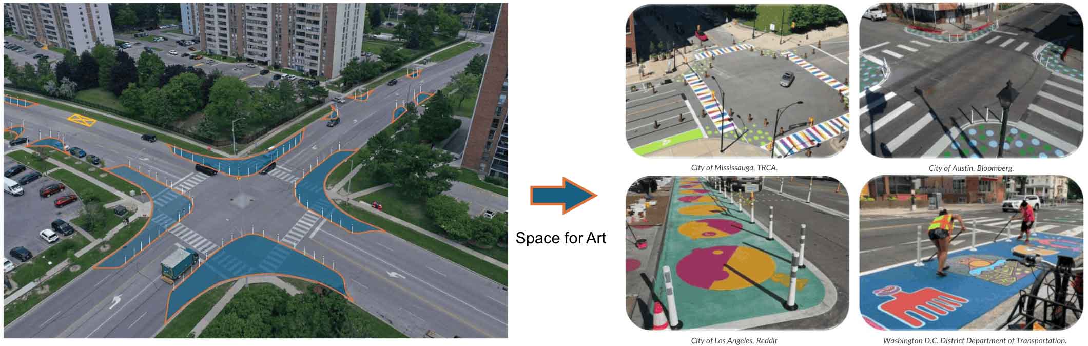
​Th​e project will focus on Kings Cross Road between Queen Street and Clark Boulevard and include major intersections at Knightsbridge Road and Kensington Road. The route links key destinations and community amenities, including the Bramalea Bus Terminal, the Chinguacousy Trail, parks, and schools.​

The initiative will enhance safety, accessibility, and livability in a high-density community while advancing Brampton’s broader goals of active transportation, youth engagement, and sustainability. The project will create safer, more engaging routes for students walking, biking, or rolling to school through art-based traffic calming. It will serve as Brampton’s first street-art-based traffic calming initiative, creating a model that can be replicated across the city and beyond.

​​

Knightsbridge Community Low Impact Development (LID) Retrofit Study

This project is a preliminary installation; the final treatment, as a part of the Knightsbridge Community LID Retrofit Study, will replace the quick-build art installation and result in green stormwater and street design enhancements. In the longer term, changes to curbs will be considered to create space for green stormwater features, as well as improvements for walking and cycling.

Help shape the future of stormwater and street improvements in Knightsbridge by completing this community survey​ before September 30, 2026. Participants who complete the survey can enter a draw to win one of four $20 PRESTO cards.​​​​

Advancing School Traffic Safety

This corridor connects to three schools: Bramalea Secondary School, Balmoral Senior Public School, and Clark Boulevard Public School, and serves as a key school route for hundreds of students. The schools, along with the Bramalea Sustainable Neighbourhood Action Plan (SNAP)​, are a part of the planning and implementation of the project.

By making school routes safer and more appealing, the project will help reduce short car trips and connect residents to the City’s active transportation network.​

Developed with extensive community consultation, the Bramalea SNAP Action Plan identified enhancements to existing pedestrian and cycling routes and the need for intersection improvements at Kings Cross Road. The project responds to community-led priorities while advancing City objectives.​

Background

King’s Cross has a five-lane cross-section and wide encourage speeding, which results in stressful conditions for pedestrians and other vulnerable road users. The area was designed for vehicles rather than people walking, cycling, or rolling.

Kings Cross has a design capacity for 36,000 vehicles per day, but Kings Cross Road carries only 3,000–5,000 vehicles daily. Between 2018 and 2022, 74 collisions were recorded in the area, including two pedestrian incidents and 12 injuries.​​​​​​​

Policy/Plan Background

This project aligns with the City of Brampton’s Active Transportation Master Plan​, Bramalea SNAP Action Plan and the City’s Public Art Strategy​, demonstrating how tactical urbanism and creative placemaking can be used together to build safer, more inclusive streets. It also aligns with the Brampton Complete Streets Guide​, Brampton Mobility Plan​, Environmental Master Plan​, Youth Engagement Strategy​, and Community Energy and Emissions Reduction Plan​.​​

Milestones

Status: Current

Late Summer 2026 – Winter 2027

The City and Bramalea SNAP will lead community engagement and consultation. Residents of Knightsbridge and the local school community will be engaged to identify safety priorities, artist selection, co-design of the murals and implementation of the murals conducted via workshops and public surveys. Additionally, community engagement will be conducted alongside the Stormwater Infrastructure Team’s LID Study.

As the project progresses, the l​ead and supporting artists creating and implementing the mural will be selected, and the mural designs will be more fully formulated.​

Status: Future

​Spring 2027 – Summer 2027

There will be the installation of the final street art and traffic calming design, which will include curb extensions, murals, and placemaking features. This will include community engagement activities, such as painting sections of the murals or complementary sidewalk art. A ribbon-cutting event or opening celebration will be organized to mark project completion.

Status: Future

Fall 2027 – Onwards

Pre and post installation data will be collected to determine changes in vehicle speeds, pedestrian activity, school commuting patterns, and community perceptions to assess safety and well-being outcomes. Two pre-studies, a public walking audit and a System of Observing Play and Recreation in Communities (SOPARC) audit will be conducted by Peel Public Health to determine initial qualitative feedback.

The installation of the Knightsbridge LID intervention will take place. The detailed design and construction timelines are awaiting confirmation.

Contact Transportation Planning